

To participate in the GlaMBIE-2 main experiment, you must contribute a unique glacier mass balance dataset that you or your team has created from one of our five observational source groups (Altimetry, Gravimetry, DEM differencing, Glaciological or Combined – a combination of different sources). The dataset should cover at least one glacier region distinct from the two ice sheets.
The methods used to produce your data submission (including uncertainty assessment) must be described in detail in an accompanying document uploaded during the submission process. These methods must also be fully documented in an international peer-reviewed journal.
As a data provider you are further encouraged to play an active role in the exercise, which includes the participation in our workshops and remaining in timely correspondence with the GlaMBIE consortium when required.
We plan to include all suitable data submitted into a future publication. All data contributors will be listed in the publication as “data contributors”. For data contributors to become co-authors of the paper we expect active involvement in the experiment. This comprises participation in the workshops and feedback to the manuscript.
By submitting your data to GlaMBIE you agree that your data will be visually displayed to other participants and the wider community (e.g. in plots during the workshop or conferences). It is the intention of the GlaMBIE community that data submitted to the assessment is made available with publication of the joint paper.
Data submission for GlaMBIE-2 main experiment opened in September 2025, and runs until the end of June 2026.
Please note that some guidelines and formatting requirements have been updated since the previous round of GlaMBIE (GlaMBIE-1, 2022–2024). Participants are advised to read this guide carefully to ensure compliance.
For the GlaMBIE experiment, contributed data are expected to fulfil the following requirements:
- Observational sources: results should be derived from the glaciological method, geodetic DEM differencing (from optical and/or radar sensors), altimetry (lidar or radar), or gravimetry. The submission of results from combined sources (e.g., glaciological and DEM differencing) is possible too.
- Spatial coverage and resolution: Results should be aggregated at regional scales, using the 19 primary glacier regions. In the second phase of the GlaMBIE main experiment, we do not collect data for partial regions or individual glaciers. Higher-resolution assessments (e.g. sub-regional or glacier-level estimates) are considered only within a dedicated pilot study. For information on how to participate in this pilot study, please get in touch via info@glambie.org.
- Temporal coverage: results should cover the longest available survey period, ideally without observation gaps.
- Temporal resolution: results should be provided at the highest temporal resolution (i.e., monthly, seasonal, annual, or multi-annual) as adequate for the corresponding observational source.
- Units: the results are expected to be submitted in the original unit of the source, these are:
- Altimetry: Elevation changes in Metres [m]
- DEM Differencing: Elevation changes in Metres [m]
- Gravimetry: Mass changes in Gigatonnes [Gt]
- Glaciological: Mass change in Metres water equivalents [m w.e.]
- Combined: Original unit [Gt, m, or m w.e.]
- Error bars: results are expected to come with uncertainty estimates to be reported at 68% OR 95% confidence intervals. Upon submission, the confidence interval applied should be clearly indicated and the associated uncertainties should be briefly described.
Resubmission of Datasets from GlaMBIE-1
Participants who submitted datasets during the first round of the GlaMBIE experiment (GlaMBIE-1, 2022-2024) are required to resubmit their data through the portal should they wish to participate in this second phase. This ensures all datasets are up-to-date, harmonised with the latest submission standards, and clearly documented for reuse and comparison. We also encourage participants to update their processing to RGI 7.0 glacier outlines.
For each dataset resubmission, you will be asked to indicate whether the dataset has previously been submitted to GlaMBIE-1 and if so, if it remains unchanged from GlaMBIE-1 or has been updated, detailing any changes or corrections made.
Region Information:
All participants are required to follow the definitions of the 19 primary glacier regions (GTN-G, 2017; RGI Consortium, 2017). For the main GlaMBIE experiment, we only accept submissions at regional level (see Table 1), and not at glacier or sub-region level.
| GTN-G ID | GTN-G Region Name | Area (km²) |
|---|---|---|
| 1 | Alaska | 86,708 |
| 2 | Western Canada & US | 14,521 |
| 3 | Arctic Canada North | 105,370 |
| 4 | Arctic Canada South | 40,538 |
| 5 | Greenland Periphery * | 90,482 |
| 6 | Iceland | 11,060 |
| 7 | Svalbard | 33,959 |
| 8 | Scandinavia | 2,948 |
| 9 | Russian Arctic | 51,595 |
| 10 | North Asia | 2,643 |
| GTN-G ID | GTN-G Region Name | Area (km²) |
|---|---|---|
| 11 | Central Europe | 2,124 |
| 12 | Caucasus & Middle East | 1,407 |
| 13 | Central Asia | 50,344 |
| 14 | South Asia West | 33,075 |
| 15 | South Asia East | 16,049 |
| 16 | Low Latitudes | 1,929 |
| 17 | Southern Andes | 27,674 |
| 18 | New Zealand | 886 |
| 19 | Antarctic and Subantarctic | 133,432 |
Table 1: The 19 glacier regions for the GlaMBIE dataset submission, including region IDs names (GTN-G, 2023) and RGI 7.0 glacier area (RGI Consortium, 2023).
Glacier Outlines:
Data submissions to the GlaMBIE experiment should preferably use version 7.0 of the Randolph Glacier Inventory (RGI), a global dataset of glacier outlines Randolph Glacier Inventory Consortium. The RGI glacier outlines can be accessed and downloaded here.
Custom glacier outlines are also accepted. However, note that the glacier areas provided in the submission files (glacier_area_reference_start and glacier_area_reference_end) will be used during the assessment to homogenise all solutions to RGI 7.0.
We recognise that not all groups will have the capacity to reprocess their datasets to RGI 7.0. We therefore also accept solutions based on earlier RGI versions (6.0 or 5.0) in cases where reprocessing would not be feasible. Where feasible, we encourage groups to provide solutions based on both RGI 7.0 and RGI 6.0. This will help assess the sensitivity of the GlaMBIE results to the choice of RGI version and evaluate the impact of the homogenisation procedure.
If submitting two versions of the same dataset (i.e. one based on RGI 7.0 and one based on RGI 6.0), please first submit the RGI 7.0 version as the main submission, and then create a second submission for the RGI 6.0 version. For clarity, we recommend appending “_RGI6” to the “Group Name” field of the second submission. For example:
- Main submission: ExampleGroup
- Second submission: ExampleGroup_RGI6
For Greenland Periphery submissions using RGI 6.0, glaciers with Connectivity Level (CL) 2 must be removed prior to submission.
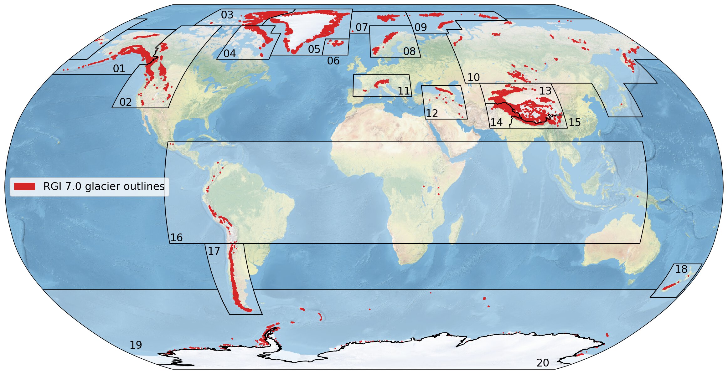
Figure 1: Global overview of the 19 first-order glacier regions (black outlines) and glacier extents (red areas). Sources: glacier outlines from RGI 7.0 (RGI Consortium, 2023).
To ensure consistency, a standard file format has been defined for all data submissions. Participants must provide their data in this format, including the required columns. Please use the provided templates for the CSV data files (all methods excluding gravimetry and gravimetry) and PDF method descriptions. Submissions in other formats will not be accepted. Each dataset will be validated upon submission, and any issues will be communicated to the authors for correction.
Expected Format and Attributes
The data file format is comma separated values (CSV), following ASCII standards.
If you are submitting multiple regions, all regions should be submitted in a single file.
The following attributes are expected to be present in each data table:
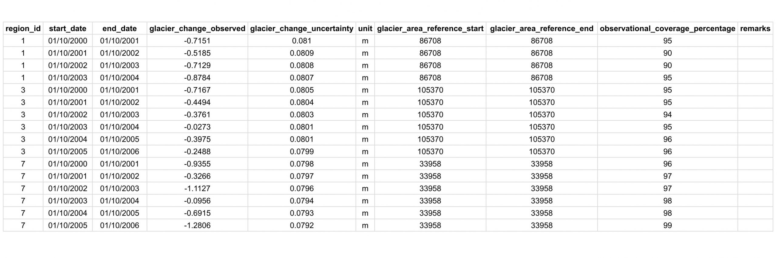
- region_id: GTN-G region ID (Table 1).
- start_date: start date of observation period in format DD/MM/YYYY.
- end_date: end date of observation period in format DD/MM/YYYY, each end date should ideally be the start date of the next observation (i.e. no temporal gaps in data). This means that the observed change is calculated from start_date to end date, excluding the day of end_date (for clarifications check the CSV example below).
- glacier_change_observed: Absolute change between start_date and end_date. NaN values will not be accepted.
- glacier_change_uncertainty: uncertainty on the observed glacier change corresponding to 68% or 95% confidence interval. Will follow the same unit as “glacier_change_observed”. NaN values will not be accepted.
- unit: the units of “glacier_change_observed” and “glacier_change_uncertainty”. Values should be either “gt”, “m”, or “mwe”.
- glacier_area_reference_start: regional glacier area (km2) assumed at start_date. If a constant area is assumed this should be equal to the regional area from RGI. This information will help to standardise the spatial domain in case area changes were applied.
- glacier_area_reference_end: regional glacier area (km2) assumed at end_date. If a constant area is assumed this should be equal to the regional area from RGI. This information will help to standardise the spatial domain in case area changes were applied.
- observational_coverage_percentage: regional glacier area (%km2) covered by observations.
- remarks: (optional) any remarks / comments.
- hydrological_correction_value: (for gravimetry submissions only), describing the hydrological correction applied for each timestep.
Example Data File
The following files are an example of the data format expected for submissions to the GlaMBIE experiment.
1) Dataset with multiple regions at annual resolution
2) Dataset with 2 multi-year time periods

The methods used to generate each data submission (including uncertainty assessment) should be described in detail in an accompanying PDF document that is uploaded during the data submission. Please use the provided template. The methods employed and the uncertainties must have been fully described in an international peer-reviewed journal.
Data Submission Checklist
File validation: Have I checked my CSV against the expected format (columns, units, no NaNs in required fields)?
Units: Have I used the correct units?
- Metres [m] for Altimetry and DEM Differencing
- Gigatonnes [Gt] for Gravimetry
- Metres water equivalents [m w.e.] for Glaciological
- Original unit [m, m w.e. or Gt] for Combined
Resubmissions: Have I indicated whether my dataset is unchanged from GlaMBIE-1 or updated, including any corrections made?
Region definition: Are my results representative at the level of one or multiple of the 19 primary glacier regions?
Uncertainty reporting: Have I provided uncertainty estimates at 68% or 95% confidence levels?
Hydrological correction (gravimetry only): If submitting gravimetry data, have I included the hydrological correction value for each timestep in the CSV?
Methodology documentation:
- Have I prepared a detailed description of the methods and uncertainty assessment as an accompanying document?
- Is the methodology published in an international peer-reviewed journal?
- Have I included figures showing spatial and hypsometric coverage of my dataset?
FAQ
Do I have to resubmit datasets already submitted to GlaMBIE-1?
Yes. All participants are required to resubmit their data to ensure that datasets are up to date, aligned with the latest submission standards, and ideally processed using RGI 7.0 outlines.
How should I format my data?
Please use the CSV data files and PDF method description templates provided below.
Can I submit glaciological data from individual glaciers to GlaMBIE?
Within GlaMBIE-2, the main experiment focuses on regionally aggregated solutions (RGI first-order regions) rather than individual glacier mass balances. However, we are also running a pilot study exploring higher spatial resolution. If you are interested in participating in this pilot which requires active involvement, please get in touch via info@glambie.org. The WGMS will submit the glaciological observations for all regions to GlaMBIE. Hence, there is no need to submit glaciological observations separately if they are already included in the WGMS database. If this is not the case, mass balances of individual glaciers are very welcomed as submissions to the WGMS database.
Can I submit an individual region only, or do I have to submit data for all regions?
We do not expect globally complete submissions from everyone and welcome data for individual glacier regions.
What happens after the data submission?
Submitted data will run through some basic quality controls. For each submitted dataset, a corresponding data quality report will be generated and identified issues discussed and (ideally solved) with the data provider.
Once the data are entered into the database some initial calculations using the GlaMBIE algorithm [RD2] will be performed to combine the data from different sources. The preliminary results and individual data contributions will be shared with the participants for feedback after the submission closes.
Any more questions?
Do not hesitate to get in touch with us at info@glambie.org!